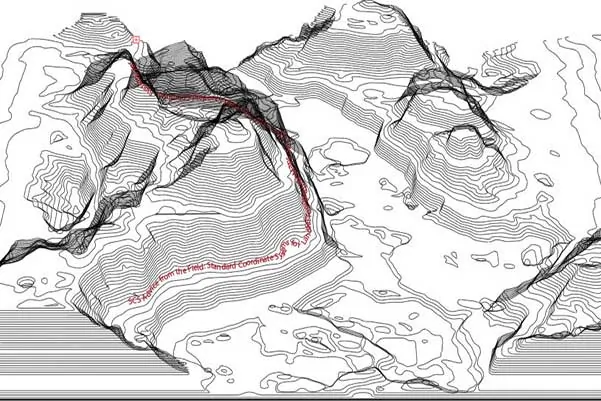
Landfill engineers rely heavily on topographic maps in their design work. Topographic maps present elevation contours, known as contour lines, for changes in the ground surface. Surveying companies create contour lines by performing land surveys, Light Detection and Ranging (Lidar) surveys, or aerial mapping. In all cases, the topographic maps are generated based on a standard coordinate system.
Basing horizontal systems on geodetic coordinates worldwide, they may be updated every few years or decades. An example of the horizontal coordinate system is the North American Datum (NAD). A datum is a formal description of the Earth’s shape and an anchor point for the coordinate system. Using the NAD system, engineers can make horizontal measurements in consideration of the anchor point information.
NAD 27 and NAD 83 are two versions of the NAD system with slightly different assumptions and measurements. A point with specific latitude and longitude in NAD 27 Datum may be tens of feet away from a point with similar latitude and longitude in NAD 83 Datum.
The latitude and longitude of an initial point (Meads Ranch Triangulation Station in Kansas) define the NAD 27 Datum. The direction of a line between this point and a specified second point and two dimensions define the spheroid. Conversely, NAD 83 Datum uses a newer defined spheroid, the Geodetic Reference System of 1980 (GRS 80). GRS 80 is an Earth-centered or geocentric datum having no initial point or initial direction.
Similarly, vertical systems provide surveyors the means to measure vertical measurements based on a standard system. Examples of the vertical datum are the National Geodetic Vertical Datum 1929 (NGVD 29) and North American Vertical Datum 1988 (NAVD 88).
Using topographic maps, solid waste engineers pay special attention to the standard coordinate system used for generating the topographic map made available to them for their design work. Engineers will want to check for additional topographic maps using another Datum for the same site. Checking eliminates the possibility of discrepancies in the design documents.
Typically, the standard system set for a landfill site remains unchanged for consistency among topographic maps generated over the years. If the standard system must change, document the conversion making it available to the solid waste engineers working at the site. The conversion information is valuable for converting engineering plans to prevent the older plans from becoming obsolete and unusable for practical engineering work.
A solid waste engineer that begins work for the first time at an existing landfill site pays special attention to the standard system (horizontal or vertical). The engineer wants to ensure the time spent producing design documents and plans aren’t wasted. For optimum efficiency, landfill owners contracting with new solid waste engineers should provide conversion information from the old to the new system upon the contract’s commencement.
The United States National Spatial Reference System NAD 83(2011/MA11/PA11) epoch 2010.00, is a refinement of the NAD 83 datum using data from a network of very accurate GPS receivers at Continuously Operating Reference Stations (CORS). A new Global Navigation Satellite System (GNSS) will replace the National Spatial Reference System NAD 83 and the NAVD 88 in 2022, according to the National Geodetic Survey Strategic Plan 2019-2023. The GNSS will rely on the global positioning system and a gravimetric geoid model resulting from the Gravity for the Redefinition of the American Vertical Datum (GRAV-D) Project. The new systems’ intention is easier access and maintenance than NAD 83 and NAVD 88, which rely on physical survey targets that deteriorate over time.
Solid waste engineers should be aware of the upcoming changes to adapt site designs as necessary and to check with landfill owners and operators to check for any implementations at their facilities.
About the Authors:
 Ali Khatami, Ph.D., PE, LEP, CGC, is a Project Director and a Vice President of SCS Engineers. He is also our National Expert for Landfill Design, Construction Quality Assurance, and Elevated Temperature Landfills. He has over 40 years of research and professional experience in mechanical, structural, and civil engineering. Dr. Khatami has been involved for more than 30 years in the design and permitting of civil/solid waste/environmental projects such as surface water management systems, drainage structures, municipal solid waste landfills, hazardous solid waste landfills, low-level radioactive waste landfills, leachate and wastewater conveyance and treatment systems, gas management systems, hazardous waste impoundments, storage tank systems, waste tire processing facilities, composting facilities, material recovery facilities, landfill gas collection and disposal systems, leachate evaporator systems, and liquid impoundment floating covers. Dr. Khatami has acquired extensive experience and knowledge in the areas of geology, hydrogeology, hydrology, hydraulics, construction methods, material science, construction quality assurance (CQA), and stability of earth systems. Dr. Khatami has applied this experience in the siting of numerous landfills.
 William Richardson, EIT is Project Professional at SCS, and part of our Young Professionals organization. Will has two years of experience with landfill design projects, including permit modifications and siting requirements. He is currently working in Virginia Beach under the tutelage of Dr. Khatami.
Corporate Headquarters