
GIS interactive maps provide geographic context and enable users to interact with mapped data using geography and visualization to tell the redevelopment story, combining maps with multimedia content. They are an engaging tool for increased transparency, accountability, and public engagement in planning for sustainable places, such as brownfields, and show in real-time project updates, providing the public with a sense of accomplishment using the latest data.
StoryMaps help build trust and encourage ongoing engagement with diverse audiences by facilitating collaboration among teams, stakeholders, agencies, and the community. It allows them to understand and even contribute insights directly through the StoryMap. Documents become interactive narratives, making it easier for wider audiences to access and understand complex planning information while facilitating information sharing and feedback.
GIS can enable the integration of various data sets related to brownfield sites, such as contamination levels, environmental risks, and remediation plans. Use it as a project management tool to manage redevelopment projects by integrating spatial and attribute data. You’ll also build an archive of historical planning data, invaluable for long-term planning, due diligence, permitting, and analysis.
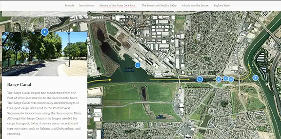
The StoryMap pictured above showcases successes and how the brownfield redevelopment provides economic opportunities to potential developers. They effectively communicate the positive impacts of brownfield redevelopment, such as job creation and increased property values. And this StoryMap highlights brownfields projects in EPA Region 5.
Where Can You Learn More?
At the 2025 Brownfields Conference in Chicago, learn the essential steps and considerations for creating an effective StoryMap, including the importance of assembling a skilled team, and discover how StoryMaps can revolutionize brownfield project communication and stakeholder engagement. Look for Megan Husic’s presentation Let Me Tell You a Story – Brownfields and StoryMaps.
Target audience: Brownfield managers, community involvement, environmental justice, developers, City Managers, brownfield grantees, private investors, local and state agencies.

About Megan Husic, CEM, is a Project Manager for SCS Engineers. She has over a decade of experience managing environmental projects, including Phase I and II Environmental Site Assessments, soil and groundwater sampling, drilling, and excavation oversight. Megan’s expertise includes managing EPA Brownfields investigation grants and working with multiple state grant and permitting agencies. She brings value to successful brownfields projects through her work and StoryMap expertise, well-received by EPA, local communities, stakeholders, and investors. If you’d like to reach out to Megan, please contact her at SCS Engineers, or on LinkedIn.