The Air & Waste Management Association is hosting its First Odour Management Conference, May 14-16, in Toronto.
The conference will cover a wide array of odour topics, including odour science, chemical forensics and source identification, field assessment methods, electronic sensing, sampling methods, policy and regulation, modeling, controls and mitigation, community impacts, and best practices. The conference builds off momentum of A&WMA’s December 2022 odour webinar related to the international olfactory laboratory standard EN13725:2022.
Look for opportunities to speak with SCS air monitoring professionals who plan to attend and present.
The Call for Abstracts is currently open through November 30, 2023.

Wind, sand, and dust storms will become more prevalent as the dry season approaches. One phenomenon that occurs during dust storms is saltation. Saltation is a method of particle transport driven by a fluid—in this case, wind.
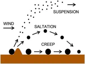
Finer particulates (<0.1mm) are generally suspended in the moving fluid, are carried into the atmosphere, and can be brought back down to the surface via precipitation. These particulates can travel over hundreds of miles. Coarser particulates (0.5 – 1mm) exhibit “soil creep,” where they roll, slide, or are pushed along with the wind, rarely coming off the surface.
Mid-range particulates—those that fall in the 0.1 – 0.5mm range—are subject to saltation. With wind speeds that hit a critical value, these particulates are carried by the wind and exhibit a lifting and falling motion, similar to bouncing. Once the particle has gained enough acceleration, it can either (1) collide with particles on the ground and dislodge them into motion at wind velocities lower than those required to move them by wind alone. This process is called reptation. Or (2) through the process of attrition, break into smaller particles upon impact and continue the loop. Saltation occurs within 30cm of the surface and accounts for 50 – 90% of the total movement of soil by wind.
Regardless of the mechanism, these Aeolian processes create ripples and dunes in the landscape. Sand accumulates on the windward side and slides down the leeward face. Both ripples and dunes are comprised of an asymmetrical wave with longer, gradual upwind slopes and shorter, steeper downwind slopes.
Sand and dust storms generally occur in arid and semi-arid regions but are also prevalent in agricultural areas and coastal zones. Notable areas in California that are subject to these storms are the Salton Sea, Mono Lake, the Central Valley area, as well as coastal dunes. These environments exhibit either sparse or nonexistent vegetation cover, plenty of fine sediment such as clay, silt, or sand, and relatively strong winds. The winds mobilize the sand and dust, resulting in major impacts on the environment, economy, and human health.
We can assess the emissions of particulates due to saltation in a few ways.
Sand Flux Measurements
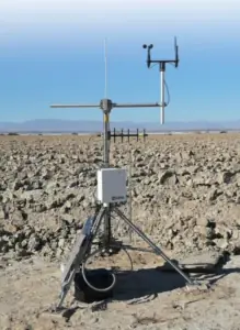
Saltating particles travel relatively small distances during wind events, so measurements of horizontal sand flux can indicate the amount of wind erosion occurring. One method for conducting sand flux measurements requires two instruments: a Cox Sand Catcher (CSC)— essentially a particle collection bin—and a Sensit—a real-time particle impact sensor. Placing the inlet of the Sand Catcher and the sensor of the Sensit at the same height, generally 15cm above the surface, assures accuracy. These two instruments are collocated at sites 100 – 1000m apart, and placing additional CSC units in the field without collocated Sensits provides better spatial resolution.
Sample tubes within the Sand Catchers are collected monthly, or more frequently during windy periods, and then delivered to the gravimetric lab for weighing. Sensits use a piezo electrical crystal to continuously detect and measure saltation activity as particle count and kinetic energy. Saltation flux is a mass measurement of particles that pass horizontally through a vertical plane; this is measured in units of mass/area, as opposed to PM concentration, measured in units of mass/volume.
Once this is determined, PM can be estimated using dispersion modeling programs such as AERMOD or CALPUFF.
Particle Counters
The SANTRI (Standalone AeoliaN Transport Real-time Instrument) is a particle counter that operates on the principle of interruptions through a wavelength of light. It counts particles as they pass through an infrared beam, detecting up to seven (7) different grain-size ranges.
SANTRIs require a solar panel and a water-resistant electrical enclosure containing a 12V lead-acid battery to provide power. The enclosure mounts on a freely rotating pole with a wind vane attached, allowing it to align with the wind direction.
One problem with the SANTRI as an optical sensor is it can overestimate particle transport when particles moving largely outside the detection beam are partially registered and counted. Alternatively, finer particles may cause insufficient attenuation of the beam signal and, in turn, are underestimated.
Particulate Matter Monitoring
Ambient particulate matter monitors such as Tapered Element Oscillating Microbalances (TEOMs) and Beta Attenuation Monitors (BAMs) log hourly concentrations of PM10 or PM2.5.
TEOMs are gravimetric instruments that pull ambient air through a filter at a constant flow rate, simultaneously weigh the filter, and calculate the real-time mass concentration.
DustTraks Monitors are real-time, near reference instruments that can measure PM1, PM2.5, Respirable, PM10, and PM Total at the same time. It uses a light-scattering photometer. Due to their low power consumption, they can deploy easily in remote areas and help develop a correlation between Saltation and PM concentration in specific areas according to the soil type.
Studies show a strong positive correlation between saltation flux and downwind PM concentrations. Measuring saltation can allow us to estimate particulate matter lofted into the air we breathe; however, the inverse isn’t always true.
Depending on the local conditions, there are different means to reduce the occurrence or compounding effects of saltation. Soil properties, topography, and meteorology are driving factors. Common methods are:
Nature can create beautiful landscapes of seemingly endless rolling waves of sand, but it can also be a major source of economic and human loss. As the climate continues to experience extremes, water scarcity and drought will further exasperate this problem in the western United States, among other regions with similar climate patterns. Lakes have been and will continue to dry and recede, exposing playa, and consequently, a major source of minerals and hyper saline particles subject to saltation.
Measurements of these natural phenomena can help us understand and plan for coexisting with nature in areas prone to wind events and storms. Measurement studies involving installing systems to quantify, assess, and control particulate matter in various locations surrounding a source—while costly and time-consuming as measurements take place on a years-long basis—are highly informative and help us adapt or create environmental solutions.
 About the Author: Ms. Eva Luu is a project manager for the SCS Engineers’ specialty Tracer Environmental practice. She has over five years of experience in ambient air monitoring, ranging from black carbon in the LA basin, and formaldehyde at the highest peak in Germany, to odor mitigation in different applications nationwide. Ms. Luu conducts routine operation and inspection of air monitoring stations as well as the calibration and operation of pollutant analyzers, meteorological sensors, chart recorders, data acquisition systems, computers, and their associated software and peripherals. She also compiles monthly air monitoring reports and submits validated, processed data for air monitoring stations to the California Air Resource Board and the Santa Barbara County APCD. Ms. Luu has conducted various odor assessment projects across the nation, ranging from alternative agriculture farms to landfills. You may reach Eva at or LinkedIn if you want more information.
If you are interested in a career where your work matters to human health and the environment as Eva’s does — we’d enjoy hearing from you!
David Hostetter, Sam Rice, Joy Stephens, and Chris Woloszyn take us on a landfill technology journey in their recent EM Magazine article. It is amazing what these YPs are developing and implementing nationwide. The future looks bright!
Most equipment data and system data are collected manually for regulatory compliance; this process is time-consuming, expensive, and sometimes dangerous. Consequently, some sites only collect a few data points per day, which may not provide a complete picture of landfill operations. They also contend with the control and maintenance of remote equipment. These YPs explain how they’ve solved these challenges using RMC and SCADA systems.
Field technicians—heavily laden with instruments, printed data collection sheets, logbooks, clipboards, maps, and other gear—spend long days collecting immense amounts of data. Additional labor awaits supervisors and managers as they transcribe, digitize, or otherwise prepare the data for analysis. This team deciphers the information recorded on sheets and logbooks, often accompanied by leachate stains, mud spatters, and water damage. GIS provides a low-cost way to streamline data collection, track progress, visualize task completion, and analyze collected data to deliver an overview of the landfill’s status.
Beyond cameras, various sensors can be attached to a drone. These sensors range from infrared cameras to LiDAR sensors to gas identification tools. One such tool helps identify the presence of methane leaking out of a landfill. A drone pilot can maneuver over the entire landfill, sniffing out methane leaks and seeking out poor landfill-cover integrity, all in a matter of hours. Drones collect methane data quickly and accurately without the need for traversing the ground on foot or by vehicle.
Integration of additional automatic and manual data collection methods, such as quarterly or annual drone flights, RMC systems, and remotely monitored and controlled wellheads, provide a comprehensive view of landfill performance and overall condition. UAVs or drones allow for safe inspections, quick data gathering, and lower operating costs.
Read EM Magazine’s full article with images here.
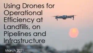
SCS is also providing a non-commercial webinar on drone technologies providing the best return on investment in March 2021. View the recording in our Learning Center after March 24, 2021.
Ann O’Brien of SCS Engineers has pulled together a list of questions that printers should be asking themselves before the environmental reporting season is upon us.
Use Ann’s questions as a guide to find out how ready your company is, and decrease your risk of non-compliance by being more organized.
If you don’t know the answers, ask Ann. She’s one of our air and water permitting, monitoring, and reporting experts at SCS. Ann specializes in printing industry compliance.
Contact and we’ll direct you to an air, storm water, wastewater, or groundwater expert near you and in your industry.
Oil and gas processing facilities, federal and local governments, landfills, land developers, contractors, industries with industrial hygiene plans can spend too much money for too little information if they don’t have an understanding of the limits and capabilities of their equipment and methods before the development of their Air Monitoring Plan (AMP) . That’s before considering the risk to their employees and to public health.
Even if you can’t afford a dedicated air monitoring group, you can eliminate the health risks, overwriting a plan, or overburdening your budget. A cost-benefit analysis and integrating stakeholders’ goals can help provide the guidance you need to develop a balanced air monitoring plan.
Start with this list of considerations when developing an Air Monitoring Plan (AMP). The list is followed by tips and suggestions which are helpful under specific circumstances.
Location of the monitoring site is initially dependent on the monitoring objective. For example, once it is known that there is a requirement to monitor for peak ambient H2S at a microscale site, it reduces the monitoring site location to specific areas. Hence, the first task when evaluating a possible site location is to determine the scale for which a candidate location can qualify by considering the following:
1. Location and emissions strengths of nearby sources, especially major source;
2. Prevailing wind direction in the area;
3. Nearby uniformity of land use;
4. Nearby population density.
To select locations according to these criteria, it is necessary to have detailed information on the location of emission sources, the geographical variability of ambient pollutant concentrations, meteorological conditions, and population density. Therefore, selection of the number, locations, and types of sampling stations is a complex process. The variability of sources and their intensities of emissions, terrains, meteorological conditions and demographic features require that each network is developed individually. Thus, selection of the network will be based on the best available evidence and on the experience of the decision team.
Developing an Air Monitoring Plan (AMP) can be a daunting task. There are many decisions to make that have downwind ramifications relative to budget, logistical constraints, and labor requirements. In addition, there may be competing goals in regards to the project stakeholders. SCS has the experience developing and implementing air monitoring plans and systems to meet these challenges; including developing site specific and network-wide AMPs for various monitoring objectives. SCS also understands the costs and demands of the implementation of AMPs on industry and government.
If you need to perform Air Monitoring or are in the initial steps of developing an AMP please contact for expert advice and guidance specific to your region and industry. We have robust programs and experts nationwide. We can also incorporate the use of remote monitoring controls and monitoring by our FCC authorized drones.
Author: Paul Schafer, SCS’ National Expert Ambient Air Monitoring
Corporate Headquarters