The U.S. Environmental Protection Agency USEPA Landfill Technology Workshop will highlight the state of advancing technologies, including their ability to detect and quantify methane and discuss how these technologies might fit into a regulatory framework. SCS Engineers’ Phil Carrillo will participate in the workshop and experts Melissa Russo, Andy Sheppard, and David Greene will be available to answer questions.
Registration is closed, but if you were not able to register before the deadline, please contact Nan Albaladejo by email () or by phone (703-705-4438) to be registered manually (if space is available). Since the workshop appears fully booked, below are some resources regarding the proven and emerging landfill methane detection and measurement technology that could work for you and the challenges they help address.
Compounded by rising labor costs and regulations, the three major challenges for landfill owners and operators are mitigating toxins, liquids, and greenhouse gases. Landfills and solid waste operations across North America use drones and remote monitoring and control applications to optimize operations and address these major challenges, including surface emissions monitoring.
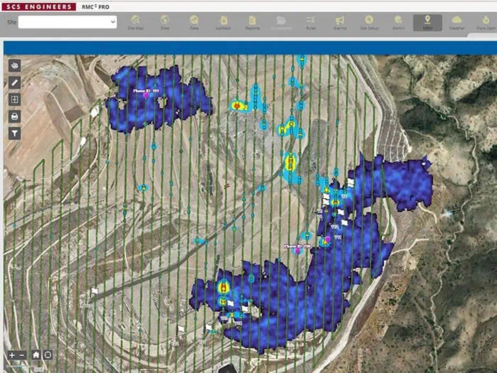
Combine sensors with SCS drone-based technologies to monitor landfill gas (LFG) emissions and detect leaks, eliminating a significant portion of the manual effort from quarterly compliance while performing operations more safely and accurately. Captured emissions data is useful for optimizing well fields, tackling odor issues, and quantifying emissions for renewable natural gas projects.
In the videos below and USEPA Landfill Technology Workshop, a 2-day meeting sponsored by the agency focuses on developing (and benefits associated with) advanced methane monitoring technologies applied to landfill monitoring. SCS Engineers expert Phil Carrillo will participate in the Technology Panel Discussion, and expert Melissa Russo will attend and be available to answer questions.
USEPA Landfill Technology Workshop covers these topics as follows,
Free, on-demand video resources
Drones, sensors, LiDAR, weather, and IoT, our landfill technology experts demonstrate how technologies work together to investigate gas collection and control systems (GCCS), liquids, airspace, stormwater, weather, wellheads, flares, pumps, temperature, and other equipment. Technology can help reduce labor and reaction time by automating what once took many hands in the field.
Video: 2024 Landfill, RNG, and Compost Monitoring Technologies Based on successful client installations, the SCS RMC team shows how landfill and facility owners/operators can respond in hours to satellite imagery of methane plumes, adjust operations to control odors based on weather conditions and collect methane emissions data in a fraction of the time it takes with traditional ground monitoring.
Video: Optimizing Landfill Technologies for Greater Efficiencies Part 1. Using drones and GIS integration for managing landfill gases and liquids. These combinations of technologies can even help you see underground conditions. It’s like having x-ray vision to manage GCCS and support leachate management while maximizing well-field pull.
Video: Optimizing Landfill Technologies for Greater Efficiencies Part 2. Panelists explain which technology is best for what and when integrating these technologies better serves your purpose and budget.
Website: USEPA Landfill Methane Outreach Program (LMOP)
Website: SCS Remote Monitoring and Control®, SCS RMC®
We are looking forward to attending the Landfill Methane Measurement Meeting. It was take place on October 29-30, 2024, at the United States Environmental Protection Agency (USEPA) Campus in Research Triangle Park, North Carolina.
This 2-day meeting is sponsored by the USEPA and will focus on the development of (and benefits associated with) advanced methane monitoring technologies as applied to landfill monitoring.
In recent years, investment in novel sensing technology for the location and remediation of methane leaks in the landfill sector has grown exponentially with the help of significant funding from the private and public sectors, including research conducted by academic institutions. The meeting is designed to highlight the state of these advancing technologies including their ability to detect and quantify methane and to discuss if/how these technologies might fit into a regulatory framework.
Technology developers, regulating agencies, researchers, regulated communities and other stakeholders interested in learning more about emerging methane detection technologies used to monitor and detect landfill methane emissions are encouraged to participate.
Registration is closed.
If you would like to attend this event and were not able to registered before the deadline, please contact, Nan Albaladejo by email () or by phone (703-705-4438) to be registered manually.
All times are in Eastern Time
Day 1 – October 29, 2024
7:30 – 8:30 Check-in with security
8:30 – 9:00 Opening Remarks – Tomás Carbonell, Deputy Assistant Administrator for Stationary Sources, Office of Air and Radiation, U.S. Environmental Protection Agency
Session 1: Setting the Stage
9:00 – 9:30 Landfill Challenges and Update on Recent Research and Findings – U.S. Environmental Protection Agency, Office of Research and Development
9:30-10:15 Method Development – U.S. Environmental Protection Agency, Office of Air Quality Planning and Standards, Measurement Technology Group
10:15-10:30 Break
10:30-12:00 Industry Panel Discussion
Research and Experiences with New Technologies
12:00 – 1:00 Lunch Break – Lunch will not be provided, but EPA’s campus does have an onsite cafeteria.
Session 2: Ground Based Approaches
1:00 – 2:45 Technology Panel Discussion
Ground Based Leak Detection – Method 21 and Beyond
2:45 – 3:00 Break
3:00 – 4:45 Technology Panel Discussion with Phil Carrillo and Melissa Russo of SCS RMC
Gas Collection and Well Tuning
4:45 Day 1 Closing Remarks – U.S. Environmental Protection Agency
Day 2 – October 30, 2024
8:00 – 8:30 Check-in with security
Session 3: Aerial Leak Detection and Quantification
8:30 – 9:45 Technology Panel Discussion
Aerial Methods Part 1
9:45 – 10:00 Break
10:00 – 11:00 Technology Panel Discussion
Aerial Methods Part 2
11:00 – 12:00 Discussion following morning panels
12:00 – 1:00 Lunch Break – Lunch will not be provided, but EPA’s campus does have an onsite cafeteria.
Session 4: Aerial Methods (Aircrafts and satellites) & Policy Discussion
1:00 – 2:45 Technology Panel Discussion
Aerial Methods – Aircraft and Satellites
2:45 – 3:00 Break
3:00 – 4:30 Discussion on Regulation of Municipal Solid Waste Landfills, U.S. Environmental Protection Agency, Office of Air Quality Planning and Standards, Natural Resources Group
4:30 Adjourning Remarks – U.S. Environmental Protection Agency
Get ready to be part of critical conversations shaping the future of landfill methane monitoring!
A Brief Regulatory History in California
On June 22, 2023, the California Air Resources Board (CARB) approved amendments to the Greenhouse Gas Emission Standards for Crude Oil and Natural Gas Facilities (Oil and Gas Methane Regulation). On November 2, 2023, CARB proposed additional modifications for public review. The public comment period ends November 17, 2023.
The Oil and Gas Methane Regulation was originally adopted in 2017 to reduce emissions by requiring:
Then in 2018, this regulation was included in California’s State Implementation Plan (SIP) to address VOC control requirements from the US EPA’s 2016 Control Techniques Guidelines (CTG) for the Oil and Natural Gas Industry. In 2022, the US EPA reviewed the SIP submittal and developed a list of deficiencies. Therefore, the Oil and Gas Methane Regulation was amended to address deficiencies and avoid sanctions under the Clean Air Act.
The Oil and Gas Methane Regulation was also amended so that CARB can use remote monitoring data from approved technologies to detect methane emission plumes and then mandate correction actions.
For example, it is anticipated that CARB will start receiving satellite data in late 2023. Once notified by CARB of a remotely detected methane plume, a facility will need to conduct inspections and repairs as well as submit reports as required by the amended regulation.
Finally, additional amendments were made to clarify the regulatory language based upon CARB’s experience with implementing the regulation over the past five years. Based on this summary in California, there is more movement in other states and not just for oil & gas facilities, but many more.
What to Expect in 2024 – Nationwide
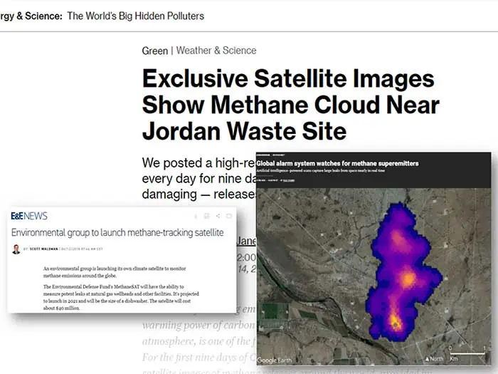
The use of satellites and Carbon Mapper are game changers. Carbon Mapper is a nonprofit entity that started flying key mission sectors and not just landfills or waste management sites. They target energy production facilities, agriculture, particularly livestock coal, mining operations, and oil and gas facilities.
The purpose is to track strong methane emissions, obviously. But the kicker is that the data is free and open to the public in the form of a methane plume overlaid on a map. The imagery usually has estimated emissions rates. Many facility owners, managers, and businesses are not aware of these monitoring events, let alone the accessibility and transparency via the Internet to the public.
Our clients reach out to us knowing that SCS has a robust drone and monitoring program – we can fly the sites and locate leak sources in hours. By using drones, our clients could respond quickly and we could identify current limitations of satellite technology for them. The resolution at a satellites high altitude does not detect and localize leak sources, but remote monitoring and control does.
Many of our clients take a proactive approach now of reoccurring drone methane inspections. We can identify areas of concern before the site is flown by manned aircraft or capture by satellites, and mitigate any potential issues ahead of making headline news. The benefit for implementing long-term operational enhancements and efficiencies prevents odors, complaints, nuisance suits, and negative headlines.
There are complementary technologies that work together, satellites, planes, drones, robot-dogs, automated wellheads, and the traditional boots on the ground. The key is combining the ones that work together to provide a more holistic view of of what’s going on at your facility. That’s where the ROI is and provides a single source to combine all data elements – so no need to move back and forth between software systems.
Questions? Contact our professionals at for immediate assistance.
Additional GHG Emissions Resources
David Hostetter, Sam Rice, Joy Stephens, and Chris Woloszyn take us on a landfill technology journey in their recent EM Magazine article. It is amazing what these YPs are developing and implementing nationwide. The future looks bright!
Most equipment data and system data are collected manually for regulatory compliance; this process is time-consuming, expensive, and sometimes dangerous. Consequently, some sites only collect a few data points per day, which may not provide a complete picture of landfill operations. They also contend with the control and maintenance of remote equipment. These YPs explain how they’ve solved these challenges using RMC and SCADA systems.
Field technicians—heavily laden with instruments, printed data collection sheets, logbooks, clipboards, maps, and other gear—spend long days collecting immense amounts of data. Additional labor awaits supervisors and managers as they transcribe, digitize, or otherwise prepare the data for analysis. This team deciphers the information recorded on sheets and logbooks, often accompanied by leachate stains, mud spatters, and water damage. GIS provides a low-cost way to streamline data collection, track progress, visualize task completion, and analyze collected data to deliver an overview of the landfill’s status.
Beyond cameras, various sensors can be attached to a drone. These sensors range from infrared cameras to LiDAR sensors to gas identification tools. One such tool helps identify the presence of methane leaking out of a landfill. A drone pilot can maneuver over the entire landfill, sniffing out methane leaks and seeking out poor landfill-cover integrity, all in a matter of hours. Drones collect methane data quickly and accurately without the need for traversing the ground on foot or by vehicle.
Integration of additional automatic and manual data collection methods, such as quarterly or annual drone flights, RMC systems, and remotely monitored and controlled wellheads, provide a comprehensive view of landfill performance and overall condition. UAVs or drones allow for safe inspections, quick data gathering, and lower operating costs.
Read EM Magazine’s full article with images here.
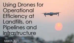
SCS is also providing a non-commercial webinar on drone technologies providing the best return on investment in March 2021. View the recording in our Learning Center after March 24, 2021.
Corporate Headquarters