Accurate digital records help landfill, waste facility, Renewable Natural Gas (RNG) plant, landfill and public works managers improve safety, make better-informed decisions, and reduce lifecycle costs for methane capture and Operations & Maintenance (O&M).
These resources offer proven precision and long-term value while addressing short-term issues, potentially saving a facility future capital by creating a sustainable view of operations and infrastructure.
In our article, we walk through a few case studies demonstrating how these technologies, in the hands of a landfill engineer, provide multiple long-term benefits.
Creating and Managing Leachate and PFAS Efficiencies
At SCS Engineers, we use drones and scanners for multiple purposes, including creating piping diagrams for a landfill gas collection and control system (GCCS) to an RNG plant or for methane destruction. Many of our clients also request scans for leachate and PFAS treatment, one of the most costly landfill operations.
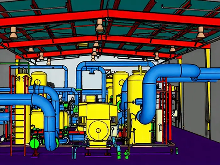
In our first example pictured above, SCS scanned a complex landfill gas compression and dehydration system, then imported the post-construction point-cloud data into the design model. We incorporated actual deviations from the design and exported the corrected model as the final as-built record.
The client benefits are immediate: a layered, three-dimensional solid image useful in CAD for future planning, design, and maintenance. Accurate drawings simplify compliance, safety, expansion, closing, and end-of-life operations.
Long-Term Benefits
Landfill information is immediately accessible during an emergency to prevent damage to the landfill’s gas and water systems. Cost savings come from avoiding retroactive replacement or correction of future infrastructure, and it can supplement an O&M database for when to replace or check current documentation and equipment.
For landfill maintenance, it’s a game changer and significantly reduces response time by having asset-level information such as component identity, installation date, expected replacement timing, manufacturer, and associated costs. This supports preventive maintenance, replacement forecasting, parts consistency, and long-term capital planning.
Permitting and Streamlining a Landfill Expansion
Visualizations can strengthen permit and build-out or landfill expansion proposals by helping site owners, municipal officials, and other stakeholders understand complex grading and expansion plans without relying solely on technical drawings. They accurately illustrate future fill areas, compare existing and proposed grades, demonstrate phased construction, and show the visual effects of mitigation measures such as berm walls and vegetation.
In this case study, engineers create realistic 3D visualizations of site expansions and modifications. The immediate benefit is for an application involving a major permit modification that requires City leadership to understand the proposed expansion’s phased development and corresponding financial impacts.
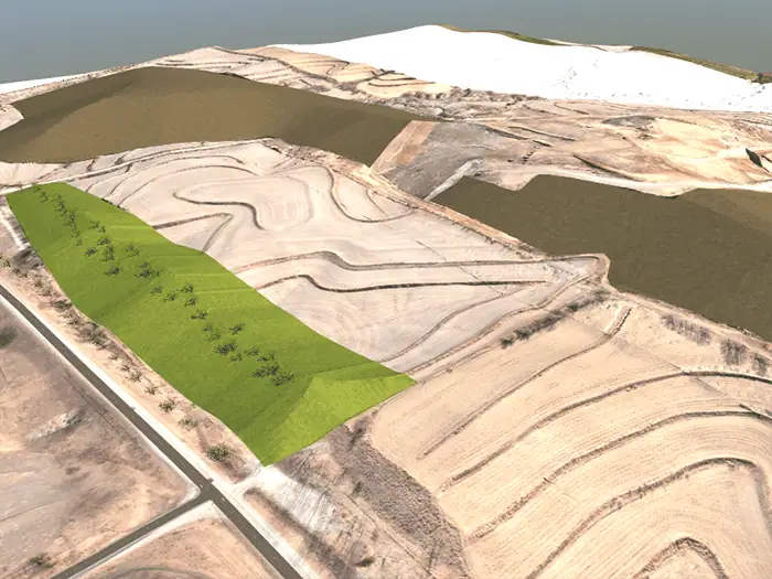
The SCS process and technology combine existing and proposed topographic surfaces from engineering drawings with recent scanned aerial imagery. Additional features—including roads, vegetation, grading, topographic shading, berms, and fill areas—can be incorporated to show how a site could look under different development scenarios. The completed model can produce still images from selected viewpoints, street-level perspectives, online renderings, and customized site videos.
This information can support decisions about details such as how high our berm should be, since the neighborhood is concerned about seeing the landfill. The technology could also support public outreach when nearby residents are concerned about proposed modifications. Showing realistic views from surrounding streets or properties would reduce uncertainty and help stakeholders evaluate potential visual impacts and understand the precautions and safety built into each design to protect the surrounding environment and public health.
In short, it helps control costs and support public outreach. “We are not all engineers who can read technical plans and blueprints. But everyone can envision the final buildout when a rendering paints the picture. This benefits technical and non-technical people alike, and is particularly useful when seeking transparency and alignment from regulators and the public, explains SCS Project Director Justin Stephenson.
Stormwater Management
Managing stormwater at a landfill is highly critical: rainwater must be routed away from trash to prevent contaminated runoff and leachate from pooling or leaking into the environment. Modeling reveals even tiny terrain low spots that are invisible to the naked eye. Engineers can use this information to quickly design infills to level the slope, input local rainfall data, and simulate a “100-year storm” to assess the design’s sustainability before construction begins.
Short- and Long-Term Value
Landfills are unique ecosystems, packed with gas extraction lines, leachate collection systems, and groundwater monitoring networks. For expansions and integrations with existing infrastructure, modeling prevents costly and dangerous construction errors. Later in the landfill’s life, this accurate record helps estimate the slope of the landfill cap and supports other long-term monitoring and operations.
Managing Agency Methane Detection with Fast Response Time and Compliance
Methane detection and the need for faster response times are rapidly changing, especially in California, Colorado, and other states pursuing stricter landfill policies.
Satellite imagery such as Carbon Mapper generally has lower resolution than drone imagery and is commonly used to identify potential hotspots that require additional investigation. Follow-up is essential, especially when it occurs soon after the observation.
Published Carbon Mapper results, for example, are available approximately a month after a flight, followed by agency or site investigation. By contrast, landfill operators can use a drone and coordinate field-services personnel on site, enabling them to check a suspected location within minutes during the same operation.
GIS and methane-flight capabilities are separate from the LiDAR process itself. For the most efficient operations, GIS databases can combine piping, gas-collection-system data, imagery, and methane-detection results for a holistic view and operational record.
Accuracy Equates to Dollars
Ground-based and drone-based LiDAR scans can create accurate existing-condition records and BIM models for landfill, waste-facility, and public-works design, permitting, operations, and maintenance. These precise 3D representations give landfill managers a reliable, reusable record of existing conditions, including complex piping and gas, water, and leachate systems. They improve safety, compliance, maintenance, emergency response, expansion planning, and design accuracy while reducing fabrication errors, rework, and lifecycle costs.
If you are interested in learning more about adopting new technologies, please get in touch with an SCS RMC expert near you or visit SCS RMC.
Additional Landfill Resources: Recent news pertaining to landfill and RNG compliance and the technologies available to owners and operators.
Corporate Headquarters